Tests done on rock have created balls-of-light -- you might call it ball lightning -- coming out of the rock. If you take a sample -- say, a column -- of rock and crush it in a powerful hydraulic press, then the rock will fracture. Interesting observations of such tests confirm balls-of-light. If such tests are performed in the dark, and videotaped at high speed, small sparks and balls-of-light can be observed coming out of the rock when it fractures.
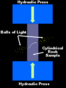
Crushed Rock Experiment (viewed in dark)
The energy to create these balls-of-light comes from the energy released at the molecular level when the rock fractures. The crystalline structure of most rocks would naturally align the atoms and molecules. This alignment would assist creating harmonic waves of energy. In other words, as the energy is released in various locations in the rock, because of the crystalline structure, the energy could align, thus facilitating the creation of balls-of-light.
Another interesting and confirming observation deals with radiation. The balls-of-light that are formed when the crushed rock fractures are not harmonic. They almost immediately decay in an explosive fashion giving off detectable electromagnetic radiation.
I imagine that the technique of crushing rock will be the most cost-effective method to demonstrate balls-of-light or ball-lightning in physics classes.
Another interesting aspect of this idea is how nature can do this on her own! Apparently -- I saw this on a television show but can not remember which one -- when earthquakes have occurred, there have been observations of glowing in the atmosphere, and of observations of huge balls-of-light -- and, sudden increases in the reports of UFO's! Obviously, if crushing a small column of rock can release observable balls-of-light, then the massive fracturing of rock in an earthquake could release massive amounts of similar energy!
See this link on the Papua New Guinea Eathquake/Tsunami that occurred July 17, 1998 where the water was described as being on fire due to the energy released in the earthquake. Often, just prior to a major earthquake, it is often reported that the sky was glowing. There are even reports of people spotting balls of light coming out of the ground. I believe this is caused by the breaking rock releasing energy.
(If you have information on this show, please E-mail me. Or, if possible, please send me a videotape to PO Box.)
The above method of crushing rock and detecting electromagnetic radiation can be used to set off short-term earthquake warning systems. For example, thousands of sensors could be placed in the ground all around California. When an earthquake starts, the characteristic electromagnetic signal given off from the electrical energy being released from the broken rock would trigger earthquake warning sirens. Thresholds could be set to limit false alarms from smaller earthquakes. Or, maybe better yet, the siren's volume could be linked to the energy released by the quake. The more the energy, the louder the siren. People would be alerted to small quakes, and a more alarming sound would be given for larger quakes.
Recently, I made a prediction that a major earthquake could occur on the dates of 10/5/1999 through 10/12/1999. During this period, two large earthquakes did occur, one in the South Pacific -- a 6.0 in magnitude -- and one in Alaska -- 6.3. Also during that time, many small earthquakes were occurring in Southern California. There were indications that a major earthquake could have happened in this area during this time frame. There was an increase of clusters of smaller quakes. One example earthquake chart looked like this.
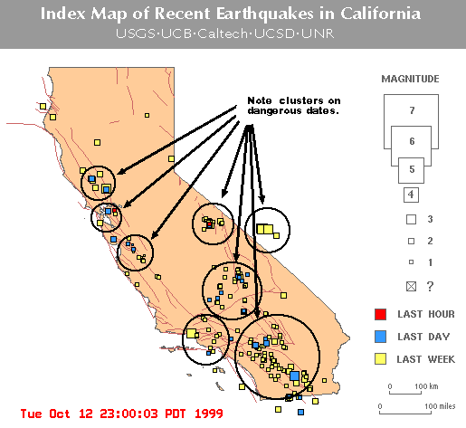
Note the clusters of earthquakes. (There were about 300 earthquakes indicated on this map.) This was a dangerous point for a major earthquake. Was the public given any warnings that a major quake could happen at any time? I am not aware of any earthquake warning or "watch" given.
Then on 10/16/1999, a major quake did occur.
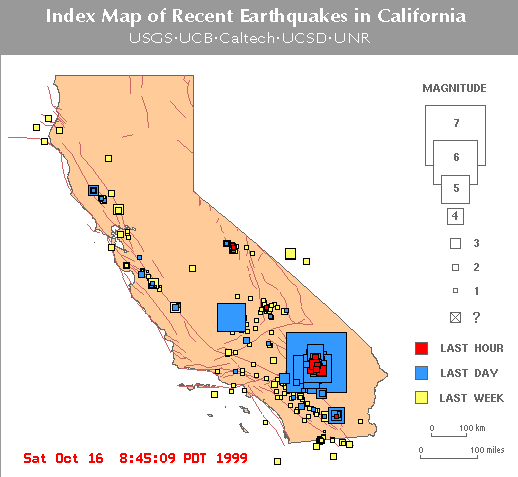
(There were about 402 earthquakes on this map.)
The biggest earthquake, the 7.1 on the 16th, did not occur during the "Dangerous" time frame that I predicted. However, I do feel that the forces that occurred between the 6th and the 12th did eventually cause the quake on the 16th. Unfortunately, my technique for predicting dangerous earthquake dates will not help much to predict this kind of delayed reaction-type quake. (The first Turkey quake, the 7.6 on 8/17/1999, was the same kind of earthquake.) The good news is my technique seems to work very well for quakes that happen immediately and major aftershocks that occur after a quake over 6.0 in magnitude.
Note: The October 16th 1999 earthquake did not just suddenly occur without warning. There were warnings. There were many smaller quakes and a 3.0 the day before, and a 3.8 on the day of the quake. Here is the data from the Global Earthquake Report.
15th October 1999   07:05 OFF COAST OF JALISCO, MEXICO     4.8 Mb   33.0 (Fair)


                    07:37 OFF COAST OF PERU                4.7 Mb   54.2 (Fair)


                    14:22 SOUTHERN CALIFORNIA        3.0 Ml    0.0 (N/A )  PAS


                    15:00 CENTRAL CALIFORNIA               3.1 Ml    6.2 (N/A )  GM


                    15:01 KURIL ISLANDS                    5.0 Mb  167.9 (Fair)


16th October 1999   02:41 SOUTHERN CALIFORNIA        3.8 Ml    6.0 (N/A )  PAS


                    08:14 NEAR E COAST OF HONSHU, JAPAN    5.1 Mb   33.0 (Good)


                    09:46 SOUTHERN CALIFORNIA        7.0 Mw   6.0 (N/A )  PAS                          (recently upgraded to a 7.1)


                    09:59 SOUTHERN CALIFORNIA              5.3 Ml   10.0 (Good)


                    11:04 SOUTHERN CALIFORNIA              4.0 Ml    6.0 (N/A )  PAS


                    11:38 SOUTHERN CALIFORNIA              4.0 Ml    3.0 (N/A )  PAS


                    11:49 SOUTHERN CALIFORNIA              4.1 Ml    6.0 (N/A )  PAS


                    12:57 SOUTHERN CALIFORNIA              5.8 Ml    1.0 (N/A )  PAS


                    16:38 SOUTH OF HONSHU, JAPAN           5.1 Mb  398.1 (Good)


                    17:48 SOUTHERN CALIFORNIA              3.7 Ml    0.1 (N/A )  PAS


                    18:05 SOUTHERN CALIFORNIA              3.8 Ml    5.6 (N/A )  PAS


                    18:10 SOUTHERN CALIFORNIA              3.7 Ml    6.0 (N/A )  PAS


                    18:13 SOUTHERN CALIFORNIA              3.5 Ml    6.0 (N/A )  PAS


                    19:39 SOUTHERN CALIFORNIA              3.6 Ml    2.3 (N/A )  PAS
Note the 3.0 and 3.8 that occurred just before the big one. Granted, not everyone can be protected from all earthquakes but more could be done. (For example, if you had a 1 or 2 minute warning of a big quake, how would you evacuate a large, or tall building?)
With all this in mind, it seems very likely that a major quake will hit Southern California during the time frame of 10/25-10/29/1999. If not by then, then the next date range that will be a major risk will be 11/5-11/11/1999.
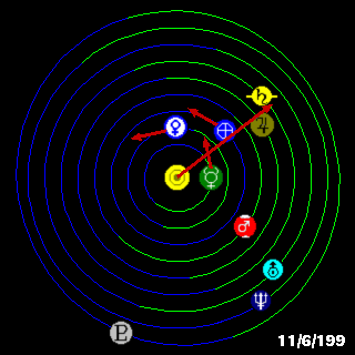
One thing that is certain, and should be kept in mind about current earthquake risk, is that the planets Jupiter and Saturn are very closely aligned. This alignment is extremely important with respect to sunspots and earthquakes. At earth's present location in its orbit -- between the sun and huge gravitational pull of Jupiter and Saturn -- the motion of our moon will be exaggerated from its normal orbit, and the forces on earth will be much higher than normal as the moon swings between being aligned with the sun, and Jupiter/Saturn.
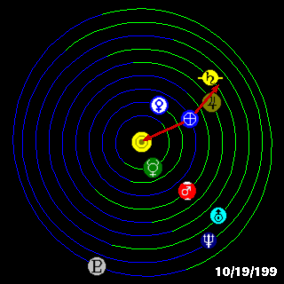
(Alignment of planets on the day this page was updated.)
Over earth's yearly orbit, the the average risk for earthquakes increases and decreases. It is definitely not constant. For example as earth approaches the gravitational pull of Jupiter, the risk increases because the forces are greater than at other times of the year. When Jupiter and Saturn align, as they are now, the risk is even greater than earth's normal approach to Jupiter. Over a long time frame, the most dangerous time frame would be when all of the planets align on the same side of the sun. Now, most astronomers discount planetary alignments as superstition. I do not. Astronomers use "tidal theory" and state that the planetary alignment could not possibly have a great enough affect to increase the risk. This is incorrect analysis. Tidal theory should not be used. Granted, the tides would not be greatly affected by the planetary alignments. However, the overall motion of the planet is affected. As proof look at the following chart.
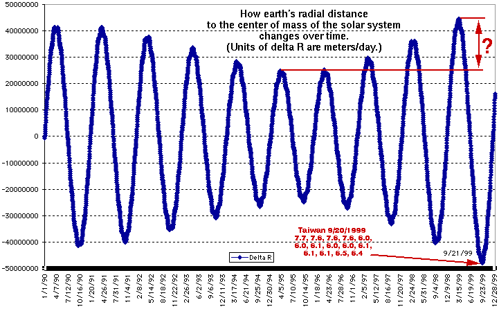
I ask you, do you see any variation in this graph? I do. To arrive at the correct conclusion, you need the correct theory. This chart shows how the radial distance between the earth and the center of mass of the solar system varies from day to day. It plots the change in radial distance in meters per day. Over this one this time frame, the primary cause of the variation is earth's gravitational interaction with Jupiter. The shorter, yearly time variation is caused by earth's cycle between perihelion and apihelion. (Closest and longest distance from the sun during yearly orbit.) Again, I ask the obvious question, after looking at this graph, does it appear that the terrible earthquakes in Taiwan were predictable, or not? If you live in an earthquake prone area, wouldn't you be interested in the plot to the right that is not shown? If you live in an earthquake prone area, wouldn't you like to see electronic sensors in the ground that automatically warn you of rock breaking underground?
The next graphic indicates how this same cycle affects sunspots.
(Alignment of planets that will greatly increase sunspots.)
See also, the related link on sunspot predictions.
Graphics of planetary alignments from http://www.fourmilab.to/solar/solar.html by John Walker.